08 Dec Functional Design Study for Bank Street from Riverside North to Ledbury
At a public consultation held on Tuesday, December 6, 2016, city officials presented the following information for residents interested in the Functional Design Study for Bank Street from Riverside North to Ledbury.
To view the presentation from Tuesday’s public open house, please click the following link:
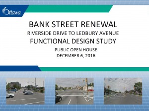
Presentation from Dec 6, 2016 Bank Street Public Open House
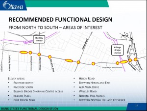
Key elements that were presented for comment include:
- Cycle tracks
- Widened sidewalks
- Transit priority measures
- Additional medians and the removal of the two way left turn lane in select locations
- Intersection designs, and
- New traffic control signals
Comments and information regarding this project will be collected to assist the project team in finalizing the design. All comments received, with the exception of personal information, will become part of the public record. You can email your comments to the project manager, Ann Selfe at ann.selfe@ottawa.ca. Deadline for Comments is January 15, 2017.
Project Overview
 The City of Ottawa has initiated a study to develop a Recommended Functional Design Plan for Bank Street from the Riverside Drive North to Ledbury Avenue. The Plan will include preliminary roadway geometry and general arrangements, typical cross sections, pavement markings, intersection details, preliminary landscape designs, and identify property requirements and project costs.
The Plan will build upon the Preliminary Design for Bank Street (Riverside Drive South to Walkley Road) completed in 2007 and will incorporate recommendations emerging from the 2012 Bank Street Community Design Plan (CDP), the 2013 Official Plan (OP) and associated Transportation Master Plan (TMP) update, and other recent studies and City policies such as the Complete Streets Implementation Framework.
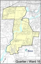
Study Area Map [ PDF 1.854 MB ]
June 28, 2016 Presentation [ PDF 2.598 MB ]
Background
The Bank Street CDP completed in 2012 is the Council-approved guide to the long-term growth and development of the portion of Bank Street from Riverside Drive to the CN rail line located south of Walkley Road (near Ledbury Avenue). The purpose of the CDP was to create a framework for the future development of these lands, which fulfills the policy direction outlined in the City’s OP and sets the specific objectives for the Bank Street community. The CDP provides the land use concept for the area, as well as the servicing and transportation structure for future development.
The City of Ottawa completed a full update to the TMP in 2013. The TMP includes recommendations and actions that support the development of Complete Streets as a component of providing safe and efficient roads.
As part of the Complete Street Implementation Framework, one of the tools identified to support the process was the development of a multi-modal level of service (MMLOS) framework. The TMP provides high level direction on how the MMLOS will be considered and outlines preliminary measures for each mode: pedestrians, cycling, transit, trucks and motor vehicles. The guideline builds upon the work of the TMP and subsequent research into MMLOS indicators to provide a detailed overview of how the MMLOS indicators are to be used and interpreted as part of the transportation impact assessment process.
Study Objectives and Schedule
The development of a Recommended Functional Design Plan will be guided by a detailed assessment of the MMLOS for pedestrians, cyclists, transit service and general traffic for existing and future travel conditions at key locations within the corridor. This analysis considers the roadway geometry and operations of each travel mode and will be used as input in the analysis of design alternatives for the Riverside Drive (North and South), Alta Vista Drive, Heron Road and Walkley Road intersections, and for the roadway segments in between.
As portions of Bank Street are designated as either a Cross-Town Bikeway or a Spine Route on the City’s Primary Urban Cycling Network (beyond 2031), a key study objective will be to incorporate cycling facilities into the Recommended Functional Design Plan. The results of the above noted MMLOS analysis will assist in identifying the need for and the degree to which protected facilities can be achieved.
As well, the study will review the need for transit signal priority and assess the feasibility of incorporating bus queue jump lanes at various intersections to address the expected increase in frequency of bus services over time needed to achieve the modal share objectives set out in the 2012 CDP.
The Recommended Functional Design Plan will be refined based on the input received from agencies, stakeholders and the public. Comments received will be considered and incorporated as appropriate into the plan and included in a final Functional Design Report.
This study is to be completed in early 2017.
How to Get Involved
The study will have the benefit of input from a Technical Advisory Committee and a Public and Business Consultation Group that will meet at key points during the study.
Updated project information will be posted periodically on the study website.
You are encouraged to participate in the study through dialogue with your local Community Association or by directly contacting Ann Selfe to have your name placed on the study mailing list to receive project updates or to submit comments and questions.
Ann Selfe, P.Eng.
Senior Implementation Engineer
Development Review (Suburban Services)
Planning and Growth Development Department
110 Laurier Avenue West, 4th Floor, Ottawa, Ontario K1P 1J1
613-580-2424 ext. 13185
Email: ann.selfe@ottawa.ca