18 Aug Hunt Club Road Cycling Link – Online Consultation Begins
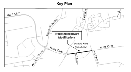
Hunt Club Road Cycling Link(Riverside Drive to Paul Benoit Driveway)
Online Consultation (for design process) : August 21 to September 20, 2017
Overview
The City of Ottawa is in the planning stage for improving quality and consistency in cycling facilities along Hunt Club Road between Riverside Drive and Paul Benoit Driveway / North Bowesville Road.
- Cycling facilities: New raised cycle track and one-way, multi-use pathway will complete a 17km long continuous route of dedicated cycling facilities on Hunt Club Road from Highway 416 to Esson Road.
- Pedestrian facilities: New sidewalks with additional separation from vehicle lanes on the south side of Hunt Club Road, new shared multi-use pathway on the north side of Hunt Club Road and proposed protected intersections at Paul Benoit Driveway and the T&T Access will make this section of Hunt Club Road safer and more comfortable for pedestrians.
- Vehicle capacity: No impacts on vehicle capacity are anticipated along Hunt Club Road.
This consultation relates to the design of the facility. Pending future funding, implementation of this facility could be planned for Phase 2 of the approved Transportation Master Plan (2020 to 2025).
Review and comment on the preliminary design
A 2.5m wide multi-use pathway is proposed on the north side of Hunt Club Road between Riverside Drive and Paul Benoit Driveway; there are currently no cycling or pedestrian facilities on this side of the road. On the south side a 1.5m cycle track and 1.8m concrete sidewalk is proposed to replace the existing concrete sidewalk between Riverside Drive and Paul Benoit Driveway. There are a number of constraints within the corridor. Where possible the new facilities have been aligned to minimize the impact on adjacent properties, mature trees and infrastructure. Nevertheless, on the north side of Hunt Club Road approximately 45 trees will be impacted by the construction. The affected trees will be replaced with 90 trees for a replacement ratio of 2:1.
Notations on the design drawing provide additional detail in accordance with the following legend:
- A – Proposed raised crosswalk and crossride
- B – Delineator strip (0.2m)
- C – Asphalt multi-use pathway (2.5m)
- D – Asphalt cycle track (1.5m)
- E – Concrete sidewalk (1.8m)
- F – Boulevard (varying width)
- G – Intersection modifications including new crossrides and bike signals
- H – Channel realigned to slow turning vehicles and improve drivers’ sightlines to pedestrians and cyclists
- I – Right turn channel removed and truck apron added to reduce radius to slow turning vehicles and improve drivers’ sightlines to pedestrians and cyclists
- J – Relocate utility/streetlighting
- K – Modify Median
- L – Relocate bus stop to far-side
- M – Modify curb and relocate catch basins
- N – Existing intersection maintained
- O – Reinforced Slope
- P – 15m Bus Platform
Tell Us What You Think
Complete our questionnaire by Sep 11, 2017.
Survey Link: https://s-ca.chkmkt.com/?e=91119&h=08B68B2301643A1&l=en
Next Steps
Comments received from the public will be considered during the detailed design phase which will be carried out in 2017 and 2018 with completion in early 2018.
For further information contact:
Amir Zahabi
Project Manager, Transportation Planning
Transportation Services
110 Laurier Avenue West
Ottawa, ON K1P 1J1
613-580-2424, ext. 16821
Email: Amir.Zahabi@ottawa.ca